


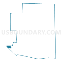
Windham 1 Voting District, Windham County, Connecticut
About
Outline

Summary
| Unique Area Identifier | 550204 |
| Name | Windham 1 Voting District |
| County | Windham County |
| State | Connecticut |
| Area (square miles) | 1.87 |
| Land Area (square miles) | 1.86 |
| Water Area (square miles) | 0.02 |
| % of Land Area | 99.14 |
| % of Water Area | 0.86 |
| Latitude of the Internal Point | 41.71942780 |
| Longtitude of the Internal Point | -72.22858630 |
Maps

Graphs
Select a template below for downloading or customizing gragh for Windham 1 Voting District, Windham County, Connecticut


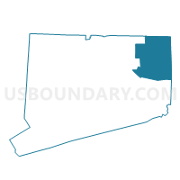
Neighbors
Neighoring Voting District (by Name) Neighboring Voting District on the Map
- Columbia 1 Voting District, Tolland County, CT
- Coventry 1 Voting District, Tolland County, CT
- Lebanon 1 Voting District, New London County, CT
- Mansfield 2 Voting District, Tolland County, CT
- Mansfield 3 Voting District, Tolland County, CT
- Windham 2 Voting District, Windham County, CT
- Windham 3 Voting District, Windham County, CT
Top 10 Neighboring County Subdivision (by Population) Neighboring County Subdivision on the Map
- Mansfield town, Tolland County, CT (26,543)
- Windham town, Windham County, CT (25,268)
- Coventry town, Tolland County, CT (12,435)
- Lebanon town, New London County, CT (7,308)
- Columbia town, Tolland County, CT (5,485)
Top 10 Neighboring Place (by Population) Neighboring Place on the Map
Top 10 Neighboring Elementary School District (by Population) Neighboring Elementary School District on the Map
Top 10 Neighboring Secondary School District (by Population) Neighboring Secondary School District on the Map
Top 10 Neighboring Unified School District (by Population) Neighboring Unified School District on the Map
- Windham School District, CT (25,268)
- Coventry School District, CT (12,435)
- Lebanon School District, CT (7,308)
Top 10 Neighboring State Legislative District Lower Chamber (by Population) Neighboring State Legislative District Lower Chamber on the Map
- State House District 54, CT (28,848)
- State House District 49, CT (25,268)
- State House District 139, CT (24,449)
- State House District 8, CT (23,861)
Top 10 Neighboring State Legislative District Upper Chamber (by Population) Neighboring State Legislative District Upper Chamber on the Map
- State Senate District 29, CT (103,291)
- State Senate District 35, CT (101,443)
- State Senate District 19, CT (100,189)
Top 10 Neighboring 111th Congressional District (by Population) Neighboring 111th Congressional District on the Map
Top 10 Neighboring Census Tract (by Population) Neighboring Census Tract on the Map
- Census Tract 8701, New London County, CT (7,308)
- Census Tract 8502, Tolland County, CT (6,931)
- Census Tract 8003, Windham County, CT (6,430)
- Census Tract 8815, Tolland County, CT (5,946)
- Census Tract 8601, Tolland County, CT (5,485)
- Census Tract 8006, Windham County, CT (4,394)
- Census Tract 8004, Windham County, CT (4,040)
- Census Tract 8007, Windham County, CT (3,397)